|
Saturday, December 20th, 2008
My mission: Take 10 hikers and myself to Red Byrd Arch, in the Clifty Wilderness, via
ridge top and bring them home alive.
The players: An assorted cast from Kywilderness.com, Redriversaga.com, 2 new guys
from Louisville and Joseph my 10 year old son.
The result: Most of them came back alive.
For
years I have wanted to set up a group hike for hikers on the net. Every time I had a “meeting” set up I ended
up going solo. I was beginning to wonder if I had a serious character flaw or that all these people never hiked…they
just sat in their basements where they dreamed and posted their pseudo adventures.
The plan was for us to
meet at the rest stop at exit #33 on the Mountain Parkway. I was very happy when people started showing up and asked if Joseph
and I were there to hike. While at the rest stop I started handing out strips of “Hunter” orange duct tape. It
was Deer season and I didn’t feel like carrying anyone out on my shoulder. I even fashioned an orange collar tag for
Lisa’s black dog Susie. It was great seeing faces of people with names like Wornoutboots, Copper Creek and KyJim.
We got the group down to 4 cars and made the trek to the “Trailhead” which was a mosh-pit, due to recent
rain, in the middle of nowhere. I have since ran my car through a carwash and it still has mud on it. We left the “parking
lot” at around 9:15 am. I “THE EXPERT GUIDE” immediately led the group down the wrong path within the first
100 feet. No harm, the correct path ran parallel to the one we were on and we quickly righted our course.
For
sake of accuracy I’ll refrain from using the word “trail” because there was none. Instead we’ll call
it a path. The first part of the path is a pot hole filled dirt forest road. From there it goes into an older (1940’s?)
overgrown forest road out the ridge top. You then take an animal path which runs out about 1000 feet from the tip of the ridge
above Red Byrd. I did have a Topo map, compass and an old GPS in hand. For that last 700 feet I strung a string to make it
easier to get back home on our return trip. That left a gap of about 300 feet between the animal path and the start of my
string line.
The path provides many obstacles along the way… mud, blow downs, and my favorite…thorns.
All in all it wasn’t a very demanding hike. As we reached the tip of the ridge top I started down into the rhodo and
securely tied a couple of ropes. The first one was tied very securely to an insecure rhodo bush. Snap. Let’s just say
it was a good thing that the ropes were only used to steady ourselves downhill through a wet and muddy area. The path we took
was literally like finding a needle in a hay stack. There was little to no room for error. One by one we safely made our way
to the beauty known as Red Byrd Arch. As we were coming down the ridge our eyes played a trick on us. We thought we saw a
cave on the adjacent ridge. As it turns out it was just a gap in the rocks.
Oddly as beautiful as the Arch
is…most people first chose to see “The Relic”. I am of course referring to the “Pink Floyd’
etched frying pan that has taken up residence at the arch. There was of course the obligatory fire ring which of course is
from a long lost tribe of nomads known as the “Beers”. They left a burnt offering to the well known King of the
Beers. I am of course referring to “Budweiser”. In an attempt to study the Beers we excavated the ring to take
back home for more study.
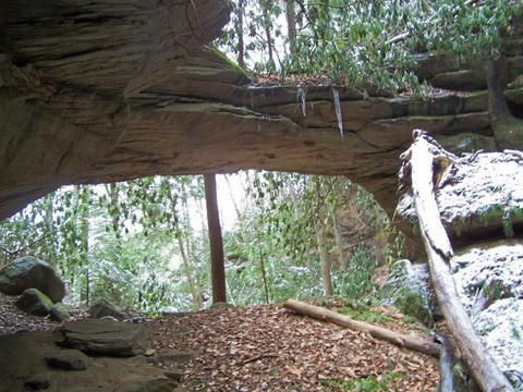
I am amazed at the lack of graffiti on Red Byrd. The fact that it is difficult
to get there has a lot to do with that. Red Byrd sits down in a hole like a cave arch. It has a waterfall that must have also
helped to form the arch. The top is covered in leaves with very little exposed rock. Under the arch is a vast area. The span
itself is not very wide but the entire structure is quite impressive. Of our group only Lisa (the one with the dog) and I
had ever been to Red Byrd before today. I felt pretty good about being able to share this with such nice people.
At the arch many pictures were taken and a few snacks shared. We stayed there about 30-40 minutes and started up the
ridge. We made a brief stop at Red Byrd Peep Site and Shelf. Having re-secured the ropes was a good idea. It made the slippery
trip up a bit easier. Once we made ridge top I had my trusty string line to guide us towards the path. We did veer off the
route to the path but with Lisa’s GPS we quickly righted our course. This beat my previous trips where I just walked
to a compass point until I ran into the pathway.
By 1:20 pm we were back to our cars. We talked about doing
another trip in the future… maybe Cloud Splitter. That will of course be discussed to death on the message boards but
I hope it will materialize soon. Thanks to all who attended. I hope we travel the same paths together again.
For the trip slideshow...click here
Email me: Click on this link
|