|
Graham Averill of Blue Ridge
Outdoors magazine recently interviewed myself and others about Red River Gorge. In turn he wrote a very nice article that
captures the essence of the Gorge. You may find this wonderful outdoors magazine at your local outdoors store.

Click on the Magazine to see the story on the Blue Ridge Outdoors website
Seeing Red
by Graham Averill on April 27, 2011
Mention the Red River Gorge to a rock climber and he’s likely to start salivating. Kentucky’s
Red has more than 200 miles of steep sandstone cliffs and has become a mecca for sport and trad climbers in the last few decades.
It is a world-class climbing destination in the East rivaled only by the New River Gorge. But mention the Red to a hiker who
might not think that clinging to a cliff by his fingertips 100 feet above the ground is a fun thing to do on a Saturday, and
you might be met with a blank stare. Particularly if that hiker hails from outside of the Bluegrass State.
“The amount of use in the Red per square foot far exceeds most other national forest units and
is actually on par with most national park units,” says Charlie Rowe, a forest service ranger who leads a volunteer
maintenance crew inside the Red. “But most of those visitors are from either Louisville or Cincinnati.”
Particularly for those of us who live on the eastern flank of the Appalachian
Mountains, we have so many outdoor destinations in our own backyard, we don’t think of driving four hours into Kentucky
to get our boots dirty. But we should. The Red River Gorge is a federally designated “Geological Area,” with the
highest concentration of natural stone arches east of the Rocky Mountains. There are more than 100 of these stone bridges
scattered throughout the 29,000-acre area, popping out of the forest like a sketch in Dr. Seuss’ notebook. It’s
as if a slice of the arch-rich Utah landscape has been transplanted to the Southern Appalachians. And every one of them is
off limits to climbers, which means the lion’s share of Red users don’t bother tracking them down.
Forget climbing,
the Red River Gorge is a paradise for hikers. This is your guide to making the most of your time in the Red, whether you’re
looking for a scenic cruise in your car or a weekend-long backpacking excursion.
Lay of the Land
The Red River Gorge
Geological Area sits inside the Daniel Boone National Forest, less than an hour east of Lexington. The Big South Fork National
Recreation Area is to the south and Breaks Interstate Park is to the east.
The Red isn’t a single gorge, it’s
a maze of narrow ridges and valleys separated by steep slopes and sandstone cliffs.
“The terrain is steep and navigation
is really tough in the gorge, even if you know the area well. When you get into one of those hollows, it’s easy to get
turned around,” says Stephanie Ross, a climber and adventure racer who has been exploring the gorge for years. The trails
are impeccably maintained and signed, thanks to the Red River Gorge Trail Crew. But getting off trail in the Red is half the
fun, since there’s rock every- where you look. Giant boulders, 200-foot cliffs, caves, and arches are often hidden right
behind a layer of rhodo as you pass by on the trail.
Scenic backcountry roads form a loop through the gorge, making trailhead
access quick and easy, and the Coombs Mountain Parkway is a four-lane road leading right to the Red’s front door.
Start
Here: Slade, Ky. There’s not much to the town of Slade, which has as many go-cart tracks as it does restaurants, but
the small burg serves as the hub of all things Red. Before you start exploring, pick up a set of maps ($16) at the Shell Station,
the unofficial welcome center to the gorge. They’re waterproof with all the topo info and hiking details you’ll
need. When you’re finished with a long day of trekking the steep slopes of the Red, grab a slice of pie at the world-famous
Miguel’s Pizza (606-663-1975).
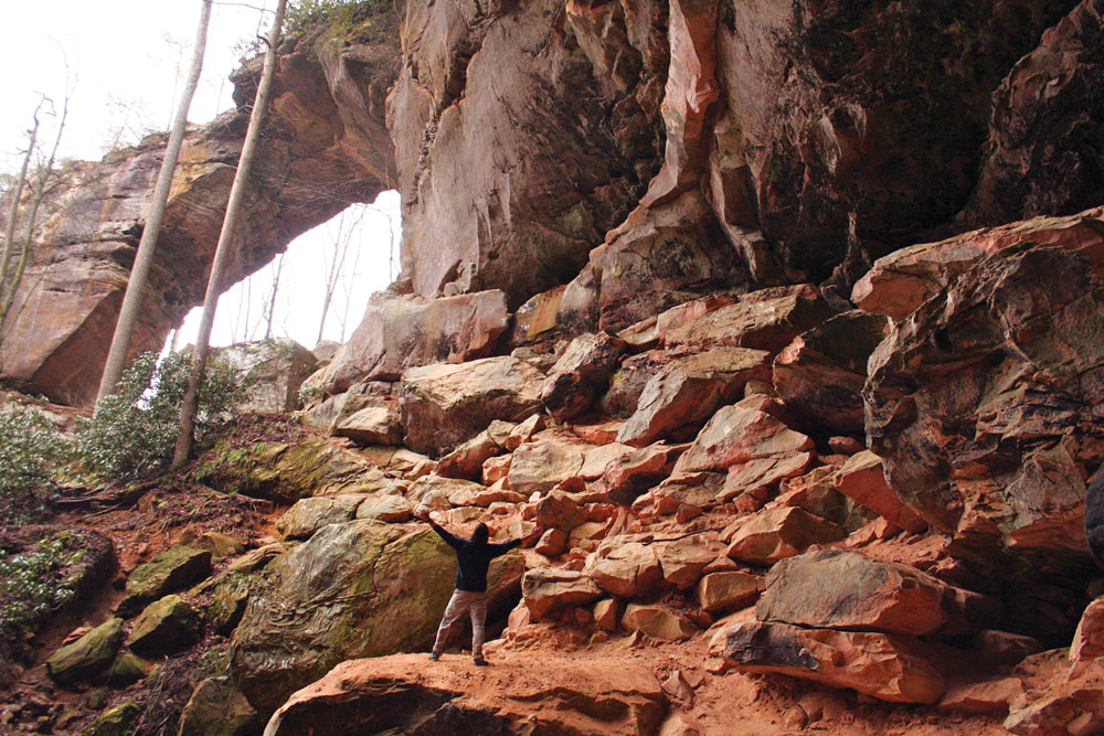
Why so many arches? The cliffs in the Red River Gorge are made up of tough sandstone
and a shale deposited from the erosion of the Appalachian Mountains 300 million years ago. Over time, streams cut through
the area eroding the shale, but leaving the harder sandstone intact. After millions of years of water and wind, we’re
left with the strikingly smooth, bizarre arches we see today. According to the Natural Arch and Bridge Society, Kentucky likely
has the second highest number of arches in the country, behind Utah and ahead of Arizona. Many of those arches are in the
Red.
The Digs
Koomer Ridge Campground: The only forest service campground in the Red, Koomer
Ridge puts you in the heart of the action, with its own set of hiking trails and arches just beyond your tent.
If you’re looking for something more primitive, there’s plenty of
car-side “backpacking” on Chimney Top Road and Auxier Ridge Road. You’ll be just a hundred yards from your
car, but you won’t have to listen to RVs or neighbors, assuming you can land one of these coveted spots. Check out the
campsite along the short, unofficial trail to Half Moon Arch, which sits on a ridgeline and has partial views of Chimney Top
Rock.
True North Inn: This hostel has bunk beds and private rooms as well as a restaurant and in-house
climbing guide service, all of which sits just a couple of miles from the border of the Clifty Wilderness.
Natural Bridge State Park Lodge: The lodge has resort-style state park digs complete with a swimming pool and buffet
dinner. The park is just a couple of miles south of the Red, across the street from Miguel’s Pizza.
The Casual Tourist
The Red is bisected by a loop of scenic, low traffic roads with trailheads branching
off in every direction. You could drive the loop without stopping in about an hour and see a number of cliffs, the Wild and
Scenic Red, and Nada Tunnel without leaving your air-conditioned car. Or you could take your time and explore a few of the
trails that begin just off the edge of the asphalt. We suggest the latter, particularly if you’re traveling with your
family. Many of the most impressive arches in the Red are easily accessible by short “nature” trails that offer
democratic hiking with big payoffs. Follow this “flight plan” and you’ll get a scenic cruise and a few leg
stretching hikes in just one afternoon.
The Drive Starting in Slade, head east on Route 15, then north on Route 715, which
is where the action begins. Route 715 is a narrow, winding mountain road that cuts through the Red, passing by massive cliffs
before joining the Wild and Scenic Red River. Complete the loop by taking Route 77 back to Route 15, passing through the 900-foot
Nada Tunnel in the process, which is only 12 feet wide and 12 feet tall.
The Hikes Route 715 is packed with hiking opportunities, both long and short.
Here are three quick leg stretchers with grand finales.
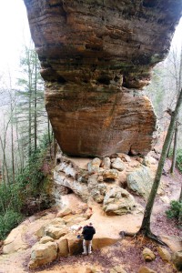
- Rock Bridge Loop: In just 1.5 miles, you’ll drop down a series of steps to the bottom of a creek
gorge, walk into a small rock shelter, pass by high cliffs, see Creation Falls (an arch in the making), and peep Rock Bridge
Arch. Swift Camp Creek runs through the middle of this sandstone arch, making a perfect natural bridge.
- Princess Arch Trail: At the end of Chimney Top Road off Route 715, the .5-mile Princess Arch Trail finishes
with a small cave and big cliff. Princess Arch is only eight feet high, but it’s 32 feet long, and as impressive as
any other rock feature in the Red. You almost feel guilty for getting this big a payoff after such a short hike.
- Angel Windows: Directly off Route 715, a .3-mile trail leads you to Angel Windows, a cliff with a series
of recessed caves and small arches. If there’s been rain, keep hiking past the windows and you’ll find a small
trickle of a waterfall over a rock shelter.
The Day Hiker
Aside from the Sheltowhee Trace, Kentucky’s long trail, the 60 miles of
trail within the gorge are ideal for day hiking. For the most part, distances between points of interest are manageable and
the high number of intersecting trails makes loops easy to configure.
“With all the short circuit hikes, it’s as if the trail system was
built with day hikers in mind,” says “Mad Mountain” Mike Hughes, a backpacker and hiker who’s been
leading trips into the gorge for three decades. Set up camp at a central location, like Koomer Ridge Campground, and then
choose from dozens of gorgeous day hikes within the Red. Here are three you shouldn’t miss.
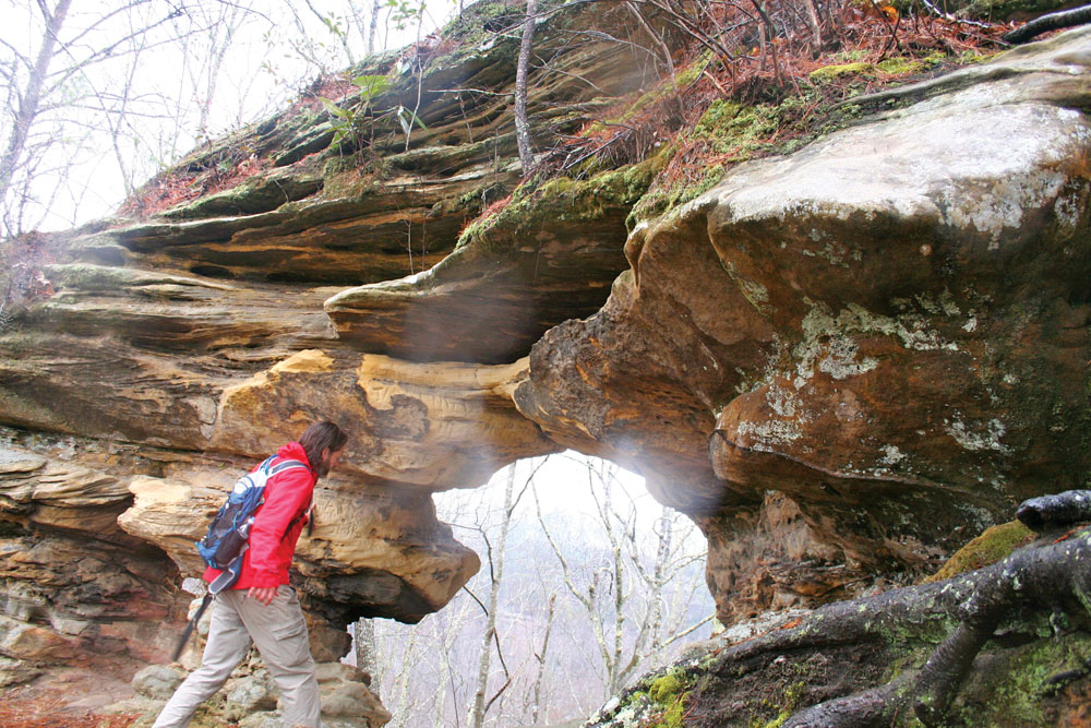
- Gray’s Arch Trail: If you’re only going to see one arch in the Red, make it Gray’s. Gray’s
starts on the edge of a cliff and spans 80 feet long and 50 feet high. Leading up to the base of the arch is a massive rock
shelter with a fine sandy floor littered with boulders for scrambling. It’s a relatively remote arch, tucked into a
ravine at the end of a 1.3-mile one-way hike on the Gray’s Arch Trail. The arch and rock shelter are so large, they
create an echo when you talk.
- Auxier Ridge: Combine the Courthouse Rock Trail and Auxier Ridge Trail for a 5-mile loop that keeps you
high on a ridgeline for good views of mini gorges and plenty of interesting rock features. Auxier Ridge is a cliff top hike
that narrows onto a sandy, rocky ridge with views of Haystack Rock and Double Arch and Raven’s Rock. The trail ends
at the base of Courthouse Rock, which has a maze of boulders and an optional scramble to the top of the massive rock feature.
Pick up Courthouse Rock Trail for a walk through the woods back to the trailhead. You could also tack on Auxier Branch and
Double Arch Trails if you wanted to turn this into an overnighter.
Sheltowee
Side Trip: Just west of the Clifty Wilderness off Route 715, hike the 0.8-mile Bison Way Trail, then hang a left on the Sheltowee
Trace Trail, a rugged backcountry path that runs for 268 miles through Kentucky. You’re only hiking the Sheltowee for
a little over a mile on this trip. Head west on the Sheltowee, passing a couple of unmarked side trails on your way to Indian
Arch, a short but impressive sandstone span along the trail. Head back the way you came, except this time take the first unmarked
trail on your left, heading steeply up the bank of the mountain. You’ll quickly find yourself at a rock and root scramble
that will lead you to the base of the Indian Staircase, a series of hand carved rock “steps” cut into the side
of an almost vertical sandstone face. At the top of the cliff, you’ll find a large rock house that’s 60 feet high
and at least 100 yards long. The unofficial trail continues east and west; both directions will take you back to the Sheltowee.
The Soul Searching Backpacker
With all of these short day-hike options, you might
think the Red has nothing to offer the “long walker,” but there’s plenty of opportunity to get deep into
the woods for several days at a time. The Sheltowee Trace runs for 26 miles through the heart of the gorge, with dozens of
loop hike options branching off in every direction. You could do a straight thru-hike of the Red’s portion of the Sheltowee
as a long weekend, or walk for weeks connecting one trail after the other in big loops. But there are a couple of smarter
options if you’re looking for weekend-long backpacking trips that offer a lot of bang for your buck.
- Swift Camp Creek Trail: The Red has its very own federally designated Wilderness,
the 12,646-acre Clifty Wilderness, which spans a rugged suite of gorges, creeks, and cliffs that get a fraction of the attention
that the rest of the area receives.
“I’ve found lost hikers in there twice,” says David “Flyingfishman”
Fisher, a backpacker who’s been exploring the Red since the ‘70s. He spends most of his time bushwhacking in search
of little-known arches, many of which sit inside Clifty. “They start out on a nature trail and end up deep inside the
Clifty Wilderness. It’s a wild area. There’s a sign at one of the trailheads: ‘We guarantee neither your
comfort nor your return.’ That says it all.”
Hike the 6.5-mile Swift Camp Creek Trail to get into the heart of this lush forest
packed with rhodo thickets, tall pine trees, and young healthy hemlocks. The trail hugs the side of the ridge 50 feet above
the creek of the same name for much of the way. Short cliffs bank the wide, slow river, while taller cliffs reach toward the
sky on either side of you. Swift Camp Creek Trail will give you the opportunity to bushwhack to see lesser known arches and
outcroppings, but the trail also passes by a couple of highlights, like Pooch’s Falls, a 25-foot vertical drop over
a cliff face with a hollowed out belly the color of rust.
Take your pick from primitive campsites as well as swimming holes with sandy beaches
abutting sheer rock faces. You’re looking at a 13-mile out and back, but this is one trail you’ll want to hike
in both directions as there’s so much to explore in this tiny rain forest.
- Rough Trail: The 8.6-mile
Rough Trail begins off of Route 77 near the Nada Tunnel and cuts through the Red to Route 715, acting as a sort of spine for
the intricate trail system. Take two cars for a shuttle, or knock this out as a 17-mile out and back. Either way, this route
gives you the best opportunity to see the most arches in the gorge.
The only major feature you’ll pass on the trail is Gray’s Arch, which is worth it on its
own, but you’ll have the opportunity for a side trip almost at every turn. Check out Military Wall, a massive cliff
popular with climbers near Rough Trail’s western trailhead.
Then pop down the Daniel Boone Hut Trail to see the cave linked to the American Legend. With possible
side trips to places like Pinch-em-Tight, Hanson’s Point, and 22 Windows. Your 17-mile weekend backpack could turn into
a week-long exercise in speed hiking. Campsites are plentiful and so is water, so Rough Trail offers relatively care-free
backpacking.
|